Geometry 对象浅析_.Net教程
推荐:再议ASP.NET DataGrid控件中的“添加新行”功能 说起在DataGrid中添加新行,ASP.NET开发的大牛人物:Dino Esposito,他的《构建WEB解决方案--应用ASP.NET和ADO.NET》一书中提供了和以上两位类似的方法,但是Dino又加了些功能,首先就是&rd
ArcEngine Geometry库定义了基本几何图形的矢量表达形式,顶级的几何图形有Points、Multipoints、Polylines、Polygons、 Multipatches,Geodatabase和绘图系统使用这些几何图形来定义其他各种形状的特征和图形,提供了编辑图形的操作方法和地图符号系统符号化特征数据的途径。
Geometry库中几个核心类和接口构成了Geometry对象的基本框架。
GeometryEnvironment
GeometryEnvironment提供了从不同的输入、设置或获取全局变量来创建几何图形的方法,以便控制geometry方法的行为。GeometryEnvironment对象是一个单例对象。
以下为引用的内容: public IPolyline TestGeometryEnvironment() public IPolyline TestGeometryEnvironment()   { { ISpatialReferenceFactory spatialReferenceFactory = new SpatialReferenceEnvironmentClass(); //Create a projected coordinate system and define its domain, resolution, and x,y tolerance. ISpatialReferenceResolution spatialReferenceResolution = spatialReferenceFactory.CreateProjectedCoordinateSystem((int)esriSRProjCSType.esriSRProjCS_NAD1983UTM_11N) as ISpatialReferenceResolution; spatialReferenceResolution.ConstructFromHorizon(); ISpatialReferenceTolerance spatialReferenceTolerance = spatialReferenceResolution as ISpatialReferenceTolerance; spatialReferenceTolerance.SetDefaultXYTolerance(); ISpatialReference spatialReference = spatialReferenceResolution as ISpatialReference; //Create an array of WKSPoint structures starting in the middle of the x,y domain of the //projected coordinate system. double xMin; double xMax; double yMin; double yMax; spatialReference.GetDomain(out xMin, out xMax, out yMin, out yMax); double xFactor = (xMin xMax) * 0.5; double yFactor = (yMin yMax) * 0.5; WKSPoint[] wksPoints = new WKSPoint[10]; for (int i = 0; i < wksPoints.Length; i ) ISpatialReferenceFactory spatialReferenceFactory = new SpatialReferenceEnvironmentClass(); //Create a projected coordinate system and define its domain, resolution, and x,y tolerance. ISpatialReferenceResolution spatialReferenceResolution = spatialReferenceFactory.CreateProjectedCoordinateSystem((int)esriSRProjCSType.esriSRProjCS_NAD1983UTM_11N) as ISpatialReferenceResolution; spatialReferenceResolution.ConstructFromHorizon(); ISpatialReferenceTolerance spatialReferenceTolerance = spatialReferenceResolution as ISpatialReferenceTolerance; spatialReferenceTolerance.SetDefaultXYTolerance(); ISpatialReference spatialReference = spatialReferenceResolution as ISpatialReference; //Create an array of WKSPoint structures starting in the middle of the x,y domain of the //projected coordinate system. double xMin; double xMax; double yMin; double yMax; spatialReference.GetDomain(out xMin, out xMax, out yMin, out yMax); double xFactor = (xMin xMax) * 0.5; double yFactor = (yMin yMax) * 0.5; WKSPoint[] wksPoints = new WKSPoint[10]; for (int i = 0; i < wksPoints.Length; i )  { wksPoints[i].X = xFactor i; wksPoints[i].Y = yFactor i; { wksPoints[i].X = xFactor i; wksPoints[i].Y = yFactor i; } IPointCollection4 pointCollection = new PolylineClass(); IGeometryBridge2 geometryBridge = new GeometryEnvironmentClass(); geometryBridge.AddWKSPoints(pointCollection, ref wksPoints); IPolyline polyline = pointCollection as IPolyline; polyline.SpatialReference = spatialReference; return polyline; } IPointCollection4 pointCollection = new PolylineClass(); IGeometryBridge2 geometryBridge = new GeometryEnvironmentClass(); geometryBridge.AddWKSPoints(pointCollection, ref wksPoints); IPolyline polyline = pointCollection as IPolyline; polyline.SpatialReference = spatialReference; return polyline; } } |
new GeometryEnvironmentClass仅仅是创建了一个指向已存在的GeometryEnvironmentClass的引用。注意 IGeometryBridge2接口的使用,addWKSPoints方法将WKSPoint二维点添加到PointCollection中,用于构建 path、ring、polyline、polygon,或增加新点到Multipoint、TriangleFan、TriangleStrip。在 Geometry库中,除了IGeometryBridge2还有IGeometryBridge接口,后者继承了前者,增加了一些编辑功能(添加点、插入点、重置点、分段等)。
GeometryBag
GeometryBag是支持IGeometry接口的几何对象引用的集合,任何几何对象都可以通过IGeometryCollection接口添加到 GeometryBag中,但是在使用拓扑操作的时候,需要注意不同类型的几何类型可能会有相互不兼容的情况。在向GeometryBag中添加几何对象的时候,GeometryBag对象需要指定空间参考,添加到其中的几何对象均拥有和GeometryBag对象一样的空间参考。
| 以下为引用的内容:private IPolygon GeometryBag_Example(IFeatureClass featureClass){ //Check input objects. if (featureClass == null) { return null; } IGeoDataset geoDataset = featureClass as IGeoDataset; ISpatialFilter queryFilter = new SpatialFilterClass(); //Set the properties of the spatial filter here. IGeometry geometryBag = new GeometryBagClass(); //Define the spatial reference of the bag before adding geometries to it. geometryBag.SpatialReference = geoDataset.SpatialReference; //Use a nonrecycling cursor so each returned geometry is a separate object. IFeatureCursor featureCursor = featureClass.Search(queryFilter, false); IGeometryCollection geometryCollection = geometryBag as IGeometryCollection; IFeature currentFeature = featureCursor.NextFeature(); while (currentFeature != null) { //Add a reference to this feature's geometry into the bag. //You don't specify the before or after geometry (missing), //so the currentFeature.Shape IGeometry is added to the end of the geometryCollection. object missing = Type.Missing; geometryCollection.AddGeometry(currentFeature.Shape, ref missing, ref missing); currentFeature = featureCursor.NextFeature(); } // Create the polygon that will be the union of the features returned from the search cursor. // The spatial reference of this feature does not need to be set ahead of time. The // ConstructUnion method defines the constructed polygon's spatial reference to be the same as // the input geometry bag. ITopologicalOperator unionedPolygon = new PolygonClass(); unionedPolygon.ConstructUnion(geometryBag as IEnumGeometry); return unionedPolygon as IPolygon;} |
Points
一个点包括X、Y坐标,同时可以增加M、Z值及ID属性来扩展点的功能。
Multipoints
点的集合,多点组成Multipoint几何类型,使用multipoint对象实现了的IPointCollection接口可以访问所有的点元素,这些点同样可以拥有M、Z值及ID属性来获得更多的地理空间内涵。
下面列举一个例子,通过一个已知的polyline来定义一个新的multipart polyline。
| 以下为引用的内容:public IPolyline ConstructMultiPartPolyline(IPolyline inputPolyline){ IGeometry outGeometry = new PolylineClass(); //Always associate new, top-level geometries with an appropriate spatial reference. outGeometry.SpatialReference = inputPolyline.SpatialReference; IGeometryCollection geometryCollection = outGeometry as IGeometryCollection; ISegmentCollection segmentCollection = inputPolyline as ISegmentCollection; //Iterate over existing polyline segments using a segment enumerator. IEnumSegment segments = segmentCollection.EnumSegments; ISegment currentSegment; int partIndex = 0;; int segmentIndex = 0;; segments.Next(out currentSegment,ref partIndex, ref segmentIndex); while(currentSegment != null) { ILine normal = new LineClass(); //Geometry methods with _Query_ in their name expect to modify existing geometries. //In this case, the QueryNormal method modifies an existing line //segment (normal) to be the normal vector to //currentSegment at the specified location along currentSegment. currentSegment.QueryNormal(esriSegmentExtension.esriNoExtension, 0.5, true, currentSegment.Length / 3, normal); //Since each normal vector is not connected to others, create a new path for each one. ISegmentCollection newPath = new PathClass(); object missing = Type.Missing; newPath.AddSegment(normal as ISegment, ref missing, ref missing); //The spatial reference associated with geometryCollection will be assigned to all incoming paths and segments. geometryCollection.AddGeometry(newPath as IGeometry, ref missing, ref missing); segments.Next(out currentSegment,ref partIndex, ref segmentIndex); } //The geometryCollection now contains the new, multipart polyline. return geometryCollection as IPolyline;} |
ISegment接口的QueryNormal方法用来在弧段上的某一点生成该弧段的法线,指定其长度,这样就生成了新的segment,并且多个path添加到geometryCollection中,以IPolyline的形式返回。
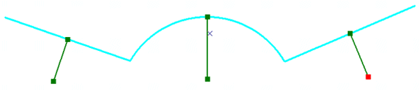
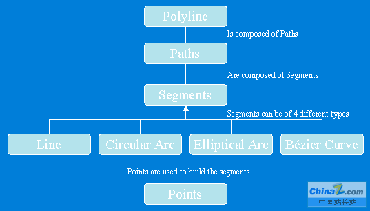
Polylines
Polylines是有序path组成的集合,可以拥有M、Z和ID属性值。Polyline对象的IPointCollection接口包含了所有节点的复制,IGeometryCollection接口可以获取polyline的paths,ISegmentCollection接口可以获取 polyline的segments。
Polyline结构图
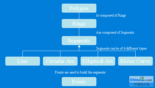
Polygons
Polygon是一系列rings组成的集合,可以拥有M、Z和ID属性值。每一个ring由一个或多个segment组成,Polygon或ring对象的IPointCollection接口包含了所有节点的复制,IGeometryCollection接口可以获取polygon的rings, ISegmentCollection接口可以获取polygon的segments。
Polygon结构图
Multipatch
Multipatch用于描述3D面状几何类型,由一系列的矢量三角形构成,如果其中的part是一个ring,那么它必须是封闭的,第一个节点和最后一个节点相同,另外每个part所包含节点的顺序非常重要,Inner Rings在Outer Rings之后,代表单个表面patch的一系列rings必须由第一个ring开始。
在9.0以后的开发包中,使用IGeneralMultiPatchCreator创建新的Multipatch,IGeometryMaterial进行材质贴图。
| 以下为引用的内容:public IMultiPatch CreateMultipatch(){ //Prepare the geometry material list. IGeometryMaterial texture = new GeometryMaterialClass(); texture.TextureImage = "C:\\Temp\\MyImage.bmp"; IGeometryMaterialList materialList = new GeometryMaterialListClass(); materialList.AddMaterial(texture); //Create the multipatch. IGeneralMultiPatchCreator multiPatchCreator = new GeneralMultiPatchCreatorClass(); multiPatchCreator.Init(4, 1, false, false, false, 4, materialList); //Set up part. //Could also use a Ring or a TriangleFan. multiPatchCreator.SetPatchType(0, esriPatchType.esriPatchTypeTriangleStrip); multiPatchCreator.SetMaterialIndex(0, 0); multiPatchCreator.SetPatchPointIndex(0, 0); multiPatchCreator.SetPatchTexturePointIndex(0, 0); //Set real-world points. WKSPointZ upperLeft = new WKSPointZ(); WKSPointZ lowerLeft = new WKSPointZ(); WKSPointZ upperRight = new WKSPointZ(); WKSPointZ lowerRight = new WKSPointZ(); upperLeft.X = 0; upperLeft.Y = 0; upperLeft.Z = 0; upperRight.X = 300; upperRight.Y = 0; upperRight.Z = 0; lowerLeft.X = 0; lowerLeft.Y = 0; lowerLeft.Z = -100; lowerRight.X = 300; lowerRight.Y = 1; lowerRight.Z = -100; multiPatchCreator.SetWKSPointZ(0, ref upperRight); multiPatchCreator.SetWKSPointZ(1, ref lowerRight); multiPatchCreator.SetWKSPointZ(2, ref upperLeft); multiPatchCreator.SetWKSPointZ(3, ref lowerLeft); //Set texture points. //Set the texture coordinates for a panel. WKSPoint textureUpperLeft = new WKSPoint(); WKSPoint textureLowerLeft = new WKSPoint(); WKSPoint textureUpperRight = new WKSPoint(); WKSPoint textureLowerRight = new WKSPoint(); textureUpperLeft.X = 0; textureUpperLeft.Y = 0; textureUpperRight.X = 1; textureUpperRight.Y = 0; textureLowerLeft.X = 0; textureLowerLeft.Y = 1; textureLowerRight.X = 1; textureLowerRight.Y = 1; multiPatchCreator.SetTextureWKSPoint(0, ref textureUpperRight); multiPatchCreator.SetTextureWKSPoint(1, ref textureLowerRight); multiPatchCreator.SetTextureWKSPoint(2, ref textureUpperLeft); multiPatchCreator.SetTextureWKSPoint(3, ref textureLowerLeft); IMultiPatch multiPatch = multiPatchCreator.CreateMultiPatch() as IMultiPatch; return multiPatch;} |
分享:AJAX实现web页面中级联菜单的设计 看了大峡搞的级联菜单,我也班门弄斧一把,嘿嘿,花了一点时间搞了个级联菜单贴上来看看。本例中只要你选择成员分类名称就会自动显示成员名称: 首先在eclipse中建一个项目,名称你自
- asp.net如何得到GRIDVIEW中某行某列值的方法
- .net SMTP发送Email实例(可带附件)
- js实现广告漂浮效果的小例子
- asp.net Repeater 数据绑定的具体实现
- Asp.Net 无刷新文件上传并显示进度条的实现方法及思路
- Asp.net获取客户端IP常见代码存在的伪造IP问题探讨
- VS2010 水晶报表的使用方法
- ASP.NET中操作SQL数据库(连接字符串的配置及获取)
- asp.net页面传值测试实例代码
- DataGridView - DataGridViewCheckBoxCell的使用介绍
- asp.net中javascript的引用(直接引入和间接引入)
- 三层+存储过程实现分页示例代码
- 相关链接:
- 教程说明:
.Net教程-Geometry 对象浅析
 。
。